Engelberg-Titlis
… 🧊 Glacier area
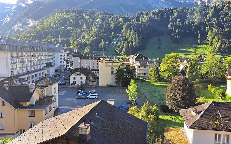
Photo: rajaraman sundaram · CC BY 3.0 · Wikimedia Commons
_2011.jpg)
Engelberg-Titlis lies in central Switzerland and is a mid-sized ski area: 82 kilometres of piste served by 26 lifts.
The area runs from 1050 to 3028 metres above sea level, giving around 1,978 metres of vertical. That takes the terrain above the 3,000-metre mark, which markedly improves snow reliability on the upper slopes.
The ski terrain reaches up to a glacier, and the season runs Oct – May. There is no summer skiing here any more, but the state of the glacier remains a live issue.
There is a snow park, an adult day pass costs CHF 78.
Of note: Titlis glacier; summer skiing ended in 2006; long season
Pistes by difficulty
- Leicht (blau)36 km44%
- Mittel (rot)38 km46%
- Schwer (schwarz)8 km10%
Distribution calculated from OpenStreetMap and applied to the 82 official kilometres of piste. An approximation, not a figure from the lift company.
Snow report
Not currentThis reading is 47 days old and is not being updated automatically at the moment. Current figures are available from the SLF and from the resort itself.
Source: SLF / WSL Institute for Snow and Avalanche Research. A single measuring station, not the resort’s official piste report.
Piste map, map & webcams
Interactive piste map
Every piste and lift colour-coded by difficulty, zoomable, built on OpenStreetMap. Community-maintained data; where it differs, the official piste map next to it is authoritative.
Open on OpenSkiMap →Official piste map
The lift company’s drawn piste map, plus lift status and tickets.
titlis.ch →Webcams
Live images from the mountain on the resort’s official site, usually several locations.
View webcams →Piste maps and webcam images belong to the lift companies and are protected by copyright. That is why we link directly to the original instead of copying it.
What sets this ski area apart
Titlis cannot be reached from the south: towards the Gadmen valley it drops away in sheer walls. Only to the north, towards Engelberg, does the ground fall at a moderate angle and form two large terraces. That is exactly where the ski area sits. Access runs in four stages via Gerschnialp, Trübsee and Stand up to the top station of Klein Titlis at 3020 metres, and that staggered layout is why it takes close to half an hour from Engelberg before you are at the top.
The final stage is the landmark: the Titlis Rotair was the world's first aerial cable car with rotating cabins. Until 2014 only the cabin floor turned; since then the whole cabin rotates through a full circle during the ride. Summer skiing on the glacier ended in 2006, but the season remains one of the longest in central Switzerland, because the upper third of the area lies consistently above 2500 metres.
Sources: de.wikipedia.org/wiki/Titlis
Snow’n’Rail at Engelberg-Titlis: up to 20% off the ski pass
This resort takes part in Snow’n’Rail, the combined offer from SBB RailAway: book the journey and the ski pass together and the pass costs less.
Snow’n’Rail Engelberg-Titlis at SBB →All resorts with Snow’n’Rail →
Getting there by public transport
Destination stop: Engelberg. Fastest connection on a Saturday morning in the currently published timetable, from the open Swiss timetable interface, retrieved 10 August 2026. A guide value, not a timetable: the real journey time depends on when you leave and what you connect to, and winter-only bus services are not yet included.
Worth knowing: this resort is in the Snow’n’Rail scheme, so the lift pass is up to 20 per cent cheaper if you arrive this way. From Zürich HB that is 1 h 43 on the train instead of behind the wheel.
Frequently asked about Engelberg-Titlis
How high is Engelberg-Titlis?
The ski area runs from 1,050 to 3,028 metres above sea level, a vertical range of 1,978 metres. For snow reliability the lower figure matters more: that is where the snow disappears first, and where a mild December is felt before it is felt at the top.
How many kilometres of piste does Engelberg-Titlis have?
82 kilometres on 26 lifts, according to the operator. There is no binding standard for measuring piste kilometres, so the figure is comparable between resorts only to a point. The lift count says at least as much about how big a place feels.
What does a day pass at Engelberg-Titlis cost?
CHF 78 for an adult day pass at the standard rate, as of summer 2026. Booked early it is often less; on a peak Saturday it is not. Arriving by public transport takes up to 20 per cent off through the Snow’n’Rail scheme.
When does Engelberg-Titlis open?
The usual season window is Oct – May. For winter 2026/27 the resort has announced 10 October 2026 as its starting date (Gletscher). Every announced date depends on enough snow and cold.
How do I get to Engelberg-Titlis by train?
The destination stop is Engelberg. From Zürich HB the fastest connection on a Saturday morning takes 1 h 43, changing 1 time; from Bern 1 h 53. A guide value, not a timetable.
Is there Snow’n’Rail at Engelberg-Titlis?
Yes. Engelberg-Titlis is one of the destinations in SBB RailAway's combined offer: book the journey and the ski pass together and the pass costs up to 20 per cent less. That percentage is the maximum SBB advertises; what actually comes off depends on the ticket type and the date, and only SBB can tell you bindingly.
Does Engelberg-Titlis have a glacier?
Yes. Glacier terrain makes the early season more reliable, because the snow layer is supported from below by ice. The summers since 2022 have shown that this is no longer a guarantee either: several Alpine glacier areas have given up summer skiing altogether.
Engelberg-Titlis in the magazine
No summer skiing left in the Alps: 24 areas have given up, four of them in three weeks
On 15 August 2026 the Stelvio was the last area to stop summer operations. Since then nobody in the Alps has been skiing in summer, for the first time. The record of 24 closures, the decade in comparison, and the reason that is not the ice.
Where you can practise transceiver searching: 27 facilities in Switzerland
More than two dozen Swiss ski areas have a permanent practice facility for avalanche transceiver searching. Use is mostly free and needs only a valid lift pass. The complete list, linked to our resort pages, and what such a facility can do.
Where freeriding happens in Switzerland: the vertical gives it away
Freeriding needs vertical drop, and our dataset holds it for all 87 areas. Zermatt leads with 2,263 metres; the median is 1,085. The analysis, what it says about the well-known freeride addresses, and where the figure misleads.
Glaciers under fleece: what the white sheets actually achieve
Around 60 per cent less ice melts under the covers. And yet the method saves no glacier at all: 0.02 per cent of Switzerland's glacier surface is covered, and covering all of it would cost over a billion francs a year. The figures, the successes and the plastic problem.
Where this resort stands
In our rankings of all Swiss ski areas:
Engelberg-Titlis is one of 2 ski areas in the canton of Obwalden, and it is quickest reached from Zurich by train, in 1 h 43.
Nearby ski areas
Distances are straight-line, not driving time. In the Alps a ridge between two valleys can turn 12 km into a two-hour drive.
Key figures
- Region
- Obwalden
- Season
- Oct – May
- Kilometres of piste
- 82 km
- Elevation
- 1050 to 3028 m (1,978 m of vertical)
- Lifts
- 26
- Adult day pass
- around CHF 78 (guide value)
- Summer skiing
- no
- Glacier
- yes
- Snow park
- rated 6/10
- Coordinates
- 46.821, 8.401
- Official website
- titlis.ch
All values are guide figures still being verified. For day-to-day information, use the resort’s official website.